Difference between revisions of "Ambalaharongana"
From MadaCamp
CampMaster (talk | contribs) |
|||
| Line 1: | Line 1: | ||
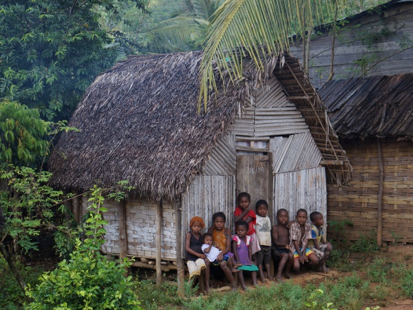
'''Ambalaharongana is a very small village in the north east of Madagascar. The village is located next to a river on the [[Masoala|Masoala Peninsula]]. Ambalaharongana has a school, two shops, a football field as well as a hotel and restaurant which offers rooms and meals to by-passers trekking between [[Maroantsetra]] and [[Antalaha]].''' | '''Ambalaharongana is a very small village in the north east of Madagascar. The village is located next to a river on the [[Masoala|Masoala Peninsula]]. Ambalaharongana has a school, two shops, a football field as well as a hotel and restaurant which offers rooms and meals to by-passers trekking between [[Maroantsetra]] and [[Antalaha]].''' | ||
| + | |||
| + | {| class="imageTable" | ||
| + | |- | ||
| + | |colspan="3" | [[File:Ambalaharongana 038.jpg|600px]] | ||
| + | |- | ||
| + | |[[File:Ambalaharongana 028.jpg|196px]] | ||
| + | |align="center"|[[File:Ambalaharongana 013.jpg|196px]] | ||
| + | |align="right"|[[File:Ambalaharongana 010.jpg|196px]] | ||
| + | |- | ||
| + | |[[File:Ambalaharongana 037.jpg|196px]] | ||
| + | |align="center"|[[File:Ambalaharongana 029.jpg|196px]] | ||
| + | |align="right"|[[File:Ambalaharongana 017.jpg|196px]] | ||
| + | |- | ||
| + | |[[File:Ambalaharongana 031.jpg|196px]] | ||
| + | |align="center"|[[File:Ambalaharongana 030.jpg|196px]] | ||
| + | |align="right"|[[File:Ambalaharongana 036.jpg|196px]] | ||
| + | |} | ||
From Ambalaharongana to [[Marofinaritra]], where the road to Antalaha starts, it takes between 3.5 and 4 hours by foot. | From Ambalaharongana to [[Marofinaritra]], where the road to Antalaha starts, it takes between 3.5 and 4 hours by foot. | ||
Revision as of 21:06, 23 February 2015
Ambalaharongana is a very small village in the north east of Madagascar. The village is located next to a river on the Masoala Peninsula. Ambalaharongana has a school, two shops, a football field as well as a hotel and restaurant which offers rooms and meals to by-passers trekking between Maroantsetra and Antalaha.

| ||

|

|

|

|

|

|

|

|

|
From Ambalaharongana to Marofinaritra, where the road to Antalaha starts, it takes between 3.5 and 4 hours by foot.
GPS Coordinates
S 15°07.843'
E050°05.570'
164m elevation
View all Ambalaharongana photos