Difference between revisions of "Ambohitrimo"
From MadaCamp
CampMaster (talk | contribs) (Created page with '<googlemap version="0.9" lat="-17.313932" lon="46.098633" zoom="15"> -18.744083, 47.552717 Amohitrimo </googlemap> Coordinates: S 18°44.645' E 047°33.163'') |
|||
| (5 intermediate revisions by one other user not shown) | |||
| Line 1: | Line 1: | ||
| − | + | '''Ambohitrimo is a small village located within a few kilometres walking distance and view of [[Ambohimanga]]'''. | |
| − | + | [[File:Ambohitrimo 001.jpg|600px]] | |
| − | |||
| − | |||
| + | <div style="max-width:600px;"> | ||
| + | {{#display_map: | ||
| + | -18.744083, 47.552717~'''Ambohitrimo'''~~; | ||
| + | |type=satellite | ||
| + | |service=google | ||
| + | |width=auto | ||
| + | |height=400 | ||
| + | |zoom=17 | ||
| + | |controls=pan, zoom, type, scale | ||
| + | |copycoords=yes | ||
| + | |icon=https://www.madacamp.com/images/madagascar/Green_marker.png | ||
| + | }} | ||
| + | </div> | ||
| − | + | GPS coordinates: S 18°44.645' E 047°33.163'<br> | |
| + | Elevation: 1293m | ||
| + | |||
| + | == Additional information == | ||
| + | |||
| + | View all [[Ambohitrimo photos]] | ||
Latest revision as of 08:19, 16 January 2021
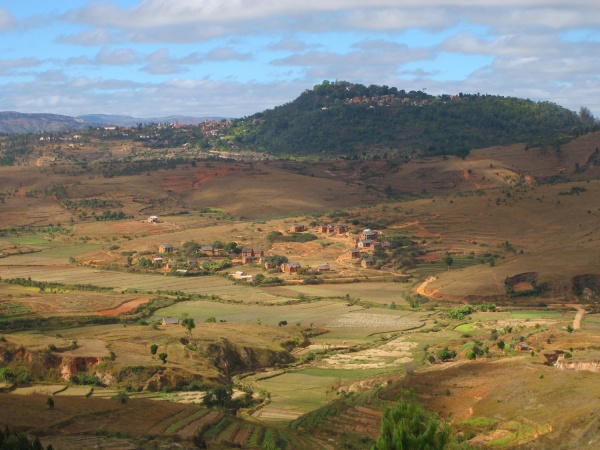
Ambohitrimo is a small village located within a few kilometres walking distance and view of Ambohimanga.

Loading map...
GPS coordinates: S 18°44.645' E 047°33.163'
Elevation: 1293m
Additional information
View all Ambohitrimo photos