Difference between revisions of "Ambohitrimo"
From MadaCamp
CampMaster (talk | contribs) m (Text replacement - "<googlemap version="0.9" (.*)>" to "<googlemap version="0.9" $1 style="width:100%;max-width:600px;">") |
|||
| Line 2: | Line 2: | ||
[[File:Ambohitrimo 001.jpg|600px]] | [[File:Ambohitrimo 001.jpg|600px]] | ||
| − | < | + | <div style="max-width:600px;"> |
| − | -18.744083, 47.552717 | + | {{#display_map: |
| − | + | -18.744083, 47.552717~'''Ambohitrimo'''~~; | |
| − | </ | + | |type=satellite |
| + | |service=google | ||
| + | |width=auto | ||
| + | |height=400 | ||
| + | |zoom=17 | ||
| + | |controls=pan, zoom, type, scale | ||
| + | |copycoords=yes | ||
| + | |icon=https://www.madacamp.com/images/madagascar/Green_marker.png | ||
| + | }} | ||
| + | </div> | ||
| − | + | GPS coordinates: S 18°44.645' E 047°33.163'<br> | |
| + | Elevation: 1293m | ||
| − | + | == Additional information == | |
| + | |||
| + | View all [[Ambohitrimo photos]] | ||
Latest revision as of 08:19, 16 January 2021
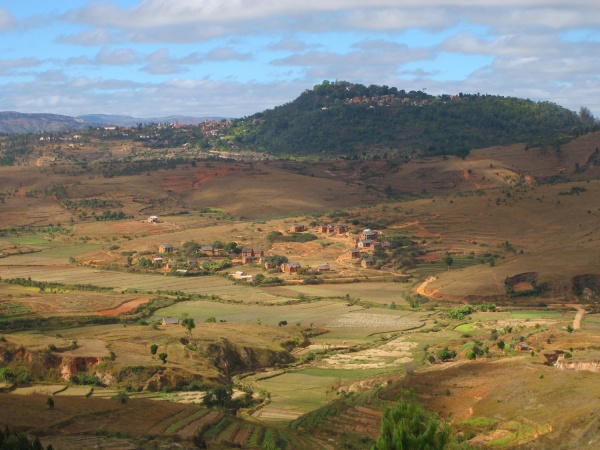
Ambohitrimo is a small village located within a few kilometres walking distance and view of Ambohimanga.

Sorry, we have no imagery here.
Sorry, we have no imagery here.
Sorry, we have no imagery here.
Sorry, we have no imagery here.
Sorry, we have no imagery here.
Sorry, we have no imagery here.
Sorry, we have no imagery here.
Sorry, we have no imagery here.
Sorry, we have no imagery here.
GPS coordinates: S 18°44.645' E 047°33.163'
Elevation: 1293m
Additional information
View all Ambohitrimo photos

