Difference between revisions of "Tsingy de Bemaraha National Park"
CampMaster (talk | contribs) (→The site and the local population) |
CampMaster (talk | contribs) (→The site and local population) |
||
| Line 93: | Line 93: | ||
* '''Illegal logging'''<br> | * '''Illegal logging'''<br> | ||
| − | The riverside population harvests timber from the forest to meet their daily needs. Therefore they target | + | The riverside population harvests timber from the forest to meet their daily needs. Therefore they target trees with a diameter between 3cm and 20cm. Very few woods with a diameter greater than 30cm are cut. The cutting period is between June and November. |
| + | |||
| + | * ''' Land clearing'''<br> | ||
| + | Land clearing is also one of the factors for forest degradation, even if the annually affected area is still minimal (1.20ha in 2001). The laying of lemur traps is one of the reasons for those clearings. | ||
| + | |||
| + | * '''Hunting'''<br> | ||
| + | Some lemur species are hunted, especially diurnal species. Most of the hunting takes place during the end of the rainy season from March to May. | ||
| + | |||
| + | * '''Collecting wildlife'''<br> | ||
| + | In recent years, wildlife species such as reptiles have been collected illegally for commercial purposes. The collection period takes place during the wet season. The caught animals are sent to the main collector in Antananarivo and from there enter the network of international wildlife trafficking. | ||
| + | Note: Since the cancellation of the Air Madagascar flight to Antsalova, this illegal practice diminished. | ||
| + | |||
| + | |||
| + | Madagascar National Park's actions are not limited to the protection and preservation of natural species. | ||
Revision as of 15:07, 12 February 2017
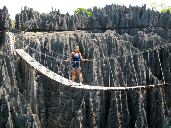
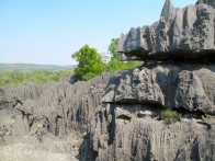
The protected area Tsingy de Bemaraha in the west of Madagascar consists of a national park and strict nature reserve. The site is unique with its biodiversity and exceptional landscape called the Tsingy - which can be translated into "where one can only walk on tiptoe". In 1990, Bemaraha was the first area in Madagascar to be classified a UNESCO World Heritage Site, and it also became a UNESCO National Cultural Heritage Site in 1991. Part of the reserve was changed to national park status in 1997.
| ||
|
|
|
Bemaraha National Park is located in the Melaky region in the central west Madagascar, about 300km from Antananarivo as the crow flies. The park stretches over an area of 157,710ha, with a length of 100km from north to south and a width of 10 to 40km from east to west. The southern part with an area of 72,340ha enjoys the status of a national park. The northern part, which is managed as an strict nature reserve, covers 85,370ha of land.
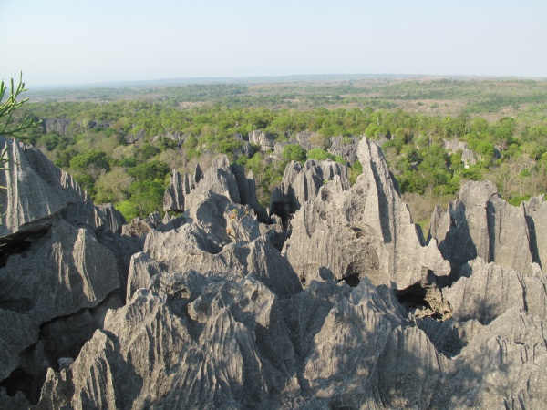
The protected area is located on the Bemaraha plateau at an altitude of 150 to 170m, a karst formation bounded to the east by steep cliffs and to the west by gentle slopes. South of the park, there is a formation of pinnacles which access is extremely difficult. In the north rolling hills alternate with limestone formations.
The Bemaraha Park is located north of the Manombolo River. The rivers coming from the plateau have a seasonal or permanent character.
The Bemaraha Massif is a very rugged limestone massif with numerous caves and an impressive canyon carved by the Manambolo River. The western part of the plateau has a very sharp relief, covered in large parts by dense dry forest. That is a true limestone cathedral which offers one of the most spectacular natural landscapes in the world. In the eastern part, the forest is intersected by savannas.
The karstic massif of Bemaraha offers a variety of natural habitats which are many different ecosystems such as dense deciduous forest, bushy xerophytic vegetation on the tsingy (limestone plateau) and sub-humid forest in the valleys or low-laying wet areas between limestone blocks as well as wooded or grassy savanna.
The park is home to lemurs, terrestrial and aquatic birds, bats, amphibians, reptiles, endemic mammals and at least 650 plant species.
The population is predominantly Sakalava. It is an ethnic group that has a conservative nature and protects it by regulations using the fady (ban or taboo).
The park enjoys a dry tropical climate marked by two contrasting seasons: Rainy from November to April and dry between May and October. The opening of the park depends on the accessibility of the dirt road connecting Morondava and Bekopaka, usually from May to November. There are various ways how to get to the park:
By car (4x4)
- Antananarivo - Morondava (600km) and then Morondava - Belo sur Tsiribihina - Bekopaka (south entrance of the park): 200km along a dirt road, 4x4 is recommended for this 8 hours stretch with at least 1 hour by ferry along the Tsiribihina River (100km north of Morondava).
- Antananarivo - Antsalova (700km): 200km paved road to Tsiroanomandidy, between Beravina and Morafeno (crossing of the Bongolava mountains) in very bad condition for over 80km. Thereafter Antsalova - Bekopaka: 100km secondary road, 4 hours by 4x4, accessible from May to November.
By taxi-brousse
- Daily departure from Antananarivo (Fasan'ny Karana station), duration 2 days.
By boat
- From Ankavandra 3 to 4 days sailing with a pirogue along the Manambolo River until Bekopaka. Ankavandra is only accessible by plane.
- From Miandrivazo 3 days by motorised pirogue down the Tsiribihina River until reaching Belo sur Tsiribihina. Thereafter along the road: Belo sur Tsiribihina - Bekopaka (100km, 4 hours by 4x4).
By plane
- Regular flights operated by Air Madagascar and Madagasikara Airways between Antananarivo and Morondava.
Contents
Management and Classification
In 1927, thanks to the biological, geological and archaeological characteristics of the Antsingy, the area was classified as Nature Reserve No. 9. Thereafter it was declared a World Heritage Site by UNESCO in 1990 and National Cultural Heritage in 1991. In August 1997, a part of the reserve was changed to national park status to allow the development of ecotourism.
Referring to the international classification of the protected area, following the categorisation by the International Union for the Conservation of Nature (IUCN), the protected complex of Tsingy de Bemaraha belongs to Category I and II. In other words, it is classified as:
- a terrestrial space comprising ecosystems, with remarkable or representative geological or physiological characteristics, managed mainly for the purpose of scientific research and/or environmental monitoring as a Strict Nature Reserve (Category I)
- a natural terrestrial area, to protect ecological integrity of one or more ecosystems for the benefit of present and future generations, to ban any exploitation or occupation incompatible with the objectives of the designation and to offer the possibility to visit for spiritual purposes following tradition, for scientific, educational, recreational and touristic reasons, while respecting the natural environment and the culture of communities, as a National Park (Category II)
Objectives of the site
Bemaraha National Park's main role is to maintain natural ecosystems, natural habitats and their biodiversity as well as exceptional natural landscapes.
Within the western ecoregion, Bemaraha is a centre of endemism both for flora and fauna. It is one of the protected areas that is the richest in faunistic species and especially in karstic ecosystems (in the western ecoregion).
The protected area Tsingy de Bemaraha complex also plays an important ecological role in the region. It is a water source for the entire downstream part of the Bemaraha plateau, especially at the level of the Manambolomaty lakes complex (one of the three RAMSAR sites in Madagascar - wetlands of international importance) and at the level of the rice granary of the region: Lake Bemamba.
The rivers draining the Antsingy are permanent streams.
It is not the rivers or streams originating in the Antsingy that are responsible for this ecological function but it is the forest cover on limestone plateau. It retains the rainwater and then allows it to infiltrate little by little and feed the springs throughout the year.
Conservation targets
Endemic species require specific conservation actions as they are subject to pressure. They are key elements in the protected area and are referred to as conservation targets.
For the protected area Tsingy de Bemaraha complex they are:
- Fauna species
- Eulemur fulvus rufus - Red-fronted lemur, threatend by hunting
- Erymnochelis madagascariensis - Madagascar big-headed turtle, endangered species
- Brookesia perarmata - Antsingy leaf chameleon, local endemic species threatened by collecting
- Uroplatus henkeli - Henkel's leaf-tailed gecko, threatened by collecting
- Habitats
- dense dry forest on limestone plateau: Highly fragmented forest formation; tpyical vegetation on karst (very fragile); natural habitat of many wildlife species
- water system: The water system that drains the Antsingy has positive impacts on the ecological balance of the region, but currently there is a slight decrease in water regime
Note: Plant species are not to be considered as conservation targets in their own right, as it is better to manage forest habitats to conserve plant species rather than to manage them individually.
The site and local population
Human pressures and their impacts are the main threats to conservation targets. Indeed, the park is subject to various pressures such as:
- Fire
The fires are periodic from June to October. Every year almost all the savanna (outside and inside the protected area) is burnt. Fortunately, the fires can not spread into the forest due to the bedrock, but mostly affect the borders.
- Illegal logging
The riverside population harvests timber from the forest to meet their daily needs. Therefore they target trees with a diameter between 3cm and 20cm. Very few woods with a diameter greater than 30cm are cut. The cutting period is between June and November.
- Land clearing
Land clearing is also one of the factors for forest degradation, even if the annually affected area is still minimal (1.20ha in 2001). The laying of lemur traps is one of the reasons for those clearings.
- Hunting
Some lemur species are hunted, especially diurnal species. Most of the hunting takes place during the end of the rainy season from March to May.
- Collecting wildlife
In recent years, wildlife species such as reptiles have been collected illegally for commercial purposes. The collection period takes place during the wet season. The caught animals are sent to the main collector in Antananarivo and from there enter the network of international wildlife trafficking. Note: Since the cancellation of the Air Madagascar flight to Antsalova, this illegal practice diminished.
Madagascar National Park's actions are not limited to the protection and preservation of natural species.
View all Tsingy de Bemaraha photos
